GoogleMap Control

The GoogleMap control allows you to display an interactive map within your Newlook form.
Client support
 Newlook Smartclient
 Newlook Server
Use
The control can be used to display a map location based on address properties. These properties can be assigned literal strings or derived from your host application fields.
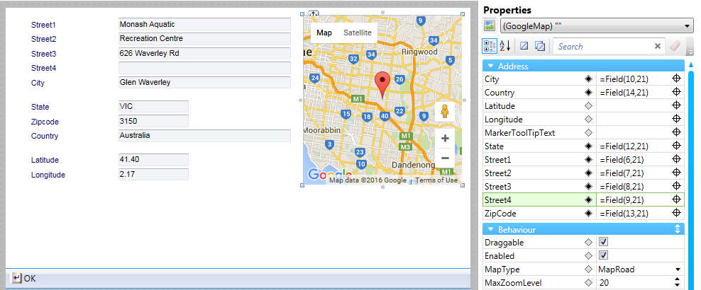
The GoogleMap control passes an address to the Google Maps API. This address determines the center point of the displayed map. The address string passed to the API can be either latitude and longitude co-ordinates, or a street address.
The street address string passed to the API is a concatenation of the following address properties ; Street1, Street2, Street3, Street4, City, State, ZipCode, Country (in this order). Not all street address properties need to be specified to create a valid address string. It is possible to specify a single address string in one of the address properties, or split the address between two or more address properties, and the address string will be constructed correctly. This is particularly useful if you have an application field that contains a single address field. You can map this field to any of the Address properties (it doesn't matter which one) and the address string will be valid.
BE AWARE THAT:
While it is possible to specify either a street address or longitude and latitude for the map location, the Address properties (Street1, Street2, Street3, Street4, City, State, ZipCode, Country) will take precedence over the Latitude/Longitude properties if both are specified.
Address properties can also be mapped to the contents of other controls on your form. For example, if you have host application fields which contain address information, you may wish to map these fields to the relevant address properties so that your map location is in sync with the current host application values.
Once an address has been specified, a marker will be placed on the map at the address location. The ToolTipText property can be used to specify custom text to display when the user hovers over the marker. If the property is left blank, the address, as determined by Google, will be displayed as the marker's hover text.
Adding a GoogleMap control with a literal address
- Open the relevant screen
in Design (
 )
mode.
)
mode. - Select Insert | GoogleMap ()
from the main menu or toolbox, then use your cursor to draw the map area on your
screen.
- With the control selected, click on the Street1, Street2, Street3, Street4, City, State, Country, Zipcode properties in turn and enter the corresponding information (if relevant). The more address properties you specify, the more accurate the mapped location will be.
Setting hover text for the map marker
- Select the ToolTipText property of your GoogleMap control and enter the text that you want to appear as the tool tip when the user hovers over the marker.
- If you wish to display the address as the tool tip then leave this property blank as this is the default setting for the marker.
Using host fields to set the address of your map
- Insert a GoogleMap control on your form.
- With the GoogleMap control selected, select the Address property that you wish to populate with the contents of a different form control (this could be a textbox on the form that contains a customer street address for example).
- Click the Field Picker (
 ) icon and select the relevant field whose contents you wish to dynamically link to the property.
 - The property entry field will be populated with a field function expression.
- Repeat this process for any other fields that you wish to map to additional Address properties. The more address properties you specify, the more accurate the mapped location will be.
Newlook Smartclient | Newlook Server |  Deprecated
|
Deprecated
|  Obsolete
|
Property |
Client |
Description |
|
|
Gets or sets the map city address |
|
|
|
The green screen column coordinate that marks the beginning of the object. Read only. Host generated controls only. |
|
|
|
Gets or sets the map address country. |
|
|
|
Gets or sets whether the map contents can be dragged by the user. |
|
|
|
Gets or sets the enabled state of the object. - limited, Newlook Smartclient-only support. |
|
|
|
Returns or sets the height of the object's size in pixels at default size, which is the object's size at design-time. |
|
|
|
Gets or sets the latitude coordinate of the map center point. |
|
|
|
Determines the distance, in pixels, between the left edge of the control and the left edge of its form or parent container at default size, which is the object's size at design-time. |
|
|
|
Gets or sets the longitude coordinate of the map center point. |
|
|
|
Gets or sets the type of map displayed in the control. |
|
|
|
Gets or sets the map marker hover text. |
|
|
|
Gets or sets the maximum zoom level. |
|
|
|
Gets or sets the minimum zoom level. |
|
|
|
Gets or sets the name of this object. |
|
|
|
The green screen row coordinate that marks the beginning of the object. Read only. Host generated controls only. |
|
|
|
Gets or sets the visibility of the map type widget on the map. |
|
|
|
Gets or sets the visibility of the pan widget (in street view). |
|
|
|
Gets or sets the visibility of a scale element on the map. |
|
|
|
Gets or sets the visibility of the street view widget on the map. |
|
|
|
Gets or sets the visibility of the zoom slider on the map. |
|
|
|
Gets or sets the map address state or province. |
|
|
|
Gets or sets the map street address (line 1). |
|
|
|
Gets or sets the map street address (line 2). |
|
|
|
Gets or sets the map street address (line 3). |
|
|
|
Gets or sets the map street address (line 4). |
|
|
|
Gets or sets a value which determines the control's tab order. |
|
|
|
Gets or sets whether the Tab key can be used to set focus to the control. |
|
|
|
Gets or sets user defined information for the control. |
|
|
|
Determines the distance, in pixels, between the top edge of the control and the top edge of its form or parent container at default size, which is the object's size at design-time. |
|
|
|
Returns a value which specifies the control's type. Read only. |
|
|
|
Gets or sets whether the control, object or form is visible or hidden. |
|
|
|
Gets or sets the width of the object in pixels at default size, which is the object's size at design-time. |
|
|
|
Gets or sets the map zip or post code. |
|
|
|
Gets or sets the initial zoom level for the map. |
See Also
IFrame control | HTML control | Field function
© 2004-2021 looksoftware. All rights reserved.